
CAPTAIN SEGULL'S NAUTICAL CHARTS, INC.
Nearshore Bethel Shoal to Fowey Rocks, FL - Laminated Nautical Navigation & Fishing Chart by Captain Segull's Nautical Sportfishing Charts | Chart # JUP35
€74,64
€124,40
-
 Order within 12 hours and 43 minutes to get between June 25 - July 1
 -
 Tracked Shipping on All Orders
-
 14-Day Returns
- Secure Payments
-
 24/7 Customer Support
Description
- Laminated Fishing Chart
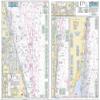
Nearshore Fishing Chart: A nearshore chart 20 to 30 miles off FloridaSide A: Winter Beach, Bethel Shoal to Jupiter Inlet and side B: Jupiter Inlet to Soldier Key, FL and Fowey Rocks. Detail insets of Fort Pierce, St Lucie, Jupiter, Lake Worth Inlet and Port of Palm Beach Inlets. Help with fishing locations from George Poveromo shows loads of local Fishing areas with local names and GPS Coordinates 19.5" x 26.5"
Shipping and Returns
- We offer tracked shipping on all orders. Tracking information will be shared as soon as the order is dispatched.
- Please check the delivery estimate before adding a product to the cart. This is displayed for every product on the website.
- Available shipping methods and charges will be displayed at the time of checkout, depending on your exact location.
- All customers are entitled to a return window of 14 days, starting from the date of delivery of the product(s).
- Customers are advised to read our return policy for details of the return process, eligibility, refunds as well as cancellations or exchanges.
- In case of any issues or concerns about Shipping or Returns, please contact us and we will be happy to help.
Captain Segull's Nautical Charts, Inc..
Nearshore Bethel Shoal to Fowey Rocks, FL - Laminated Nau...
€74,64
€124,40